This is not another hoax or false claim. The discovery was based on years of dedication and preparation by a research team of professional archaeologists and historians, the First Colony Foundation.
First Colony Foundation’s Search for Raleigh’s Lost Settlers
Having led excavations for Colonial Williamsburg in the past, they have an international reputation for their fieldwork on the earliest English colonial sites in Virginia, Ireland, and the Caribbean.
We of First Colony have focused on Sir Walter Raleigh’s colonial settlement on Roanoke Island, inland from North Carolina’s easterly, dangerous Cape Hatteras, called the Graveyard of the Atlantic for its rough seas and its far-reaching shoals.
Excavating Roanoke Island and Fort Raleigh
The site of that settlement is well-known to history, and one small piece of it is the earthwork Fort Raleigh National Historic Site of the U.S. National Park Service. Unfortunately, centuries-long coastal erosion and sand dune formation have both destroyed and covered over much of the settlement.
With NPS permission, twenty years of First Colony excavations have brought to light many details of the 1585 expedition that used Roanoke as its base for exploring Raleigh’s new province, named Virginia after the firmly unmarried Queen Elizabeth I.
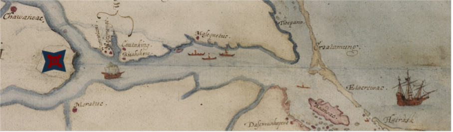
The 2012 Map Discovery That Changed Everything
But our research soon changed when, in 2012, we asked a First Colony board member to determine if the British Museum knew what lay underneath two small paper patches on the famous Elizabethan map of the Carolina coast.
It had been drawn for Raleigh by the artist John White after he visited the coast in 1585. The museum’s response soon made headlines.
A Hidden Fort Symbol Reveals a New Clue
Underneath a patch at the west end of the Albemarle Sound, in today’s rural Bertie County, was the symbol of a Renaissance-style fort.
When the colonists in 1587 reported that they planned to move fifty miles into the mainland, the symbol proved that the destination was not north toward the Chesapeake Bay, as many historians had assumed, but due west.
Following the Evidence Along the Chowan River
There the previous year’s explorers had found good, high ground for crops and the deep Chowan River, where lived a tribe friendly to the English. Sir Walter Raleigh’s own artist had hidden the clue to the location of the Lost Colony.
As one of our members said, “We have found the haystack, and now we must find the needle.”
We started looking through archives for a document referring to unusual finds or ruins. Nothing appeared.
Then, a National Geographic Society grant added satellite imaging to our search. If there had been a real fort—not just a symbol indicating where the colony should be planted—it should be visible from the air.
Again, we struck out.
Site X: The First Elizabethan Settlement Found on the American Mainland
Some archaeological work had taken place in the area, however, and by searching through all the collected finds, our artifact experts hoped to identify something from the late 1500s.
This avenue of research soon brought results.
Discovering Elizabethan Artifacts in Bertie County
On one site, a few English pottery sherds of possible sixteenth-century date had been found among later artifacts. It lay at the mouth of a creek deep enough for ships to navigate.
We knew nothing more about it, so we called it Site X.
Scientific Methods Behind the Discovery
First Colony recognized that this had the potential to change American history, but we followed strict scientific procedures. Everything unearthed was preserved for study. Every layer and feature was measured, drawn, and photographed. Access to the site was strictly controlled.
Proving Site X Was Connected to the Lost Colonists
Despite significant later disturbances, Site X proved to be the first Elizabethan site discovered on the mainland of the United States.
The site had also been used by Algonquian Indians, who remained nearby in the palisaded town of Mettaquem.
A Lead Cloth Seal Provides Crucial Evidence
The breakthrough came when close examination of a thumb-sized lump of lead revealed it to be a late sixteenth-century cloth seal from Augsburg, Germany.
This find strongly suggested the presence of civilian colonists rather than soldiers from the earlier Lane expedition.
Site Y: Expanding the Search for the Lost Colony
Upstream, our continued search located the larger Site Y.
Although serious erosion had damaged the site over the centuries, we unearthed many more Elizabethan artifacts there than at Site X, creating the largest collection of Elizabethan artifacts ever found in America.
Evidence of a Larger Colonial Settlement
If Site X represented one small group of settlers, Site Y appeared to contain evidence of three or four times that number.
Unlike Site X, no Native artifacts were found there, suggesting a more independent English settlement.
How the Lost Colony of Roanoke Was Finally Found
Thus, we have proven that Site X was not unique. Site X and Site Y were part of a larger, dispersed settlement of farms along the Chowan River, where 117 immigrants established their New World home.
The settlement lay only fifty miles from Roanoke Island, but that fragile connection was soon broken when the Spanish Armada threatened England.
The Legacy of the Lost Colony Discovery
No ships ever reached the colony again. Abandoned by history and separated from England, the settlers became the Lost Colony—until now.