Approximately 7,000 Indians inhabited Ossomocomuck (coastal North Carolina), from the Great Dismal Swamp in the north to the Neuse River in the south. They were loose groupings of semi-autonomous peoples rather than centralized political entities controlled by powerful rulers.
Algonquian-Speaking People in 16th Century America
Three major peoples, the Chowanocs, Weapemeocs, and Secotans, inhabited the region in the late sixteenth century, all Algonquian-speaking peoples descended from ancestors who moved into the mid-Atlantic region thousands of years earlier. The Chowanocs were the most numerous and were ruled by an old and experienced chief called Menatonon.
They lived in towns and small settlements scattered along the western bank of the Chowan River and lower reaches of the Merherrin and Blackwater. Their capital, Chowanoc, was situated on a bluff overlooking the Chowan River and had been inhabited for centuries. The town was made up of a central core of longhouses, storehouses, temples, and public spaces surrounded by the dwellings.
Weapemeoc Territory
The territory from the Chowan River to Currituck Sound was occupied by the Weapemeocs, ruled by a chief called Okisko, who was subject to Menatonon. Most of their settlements bordered the northern shore of Albemarle Sound or were located on its tributaries, but their lands extended northwards at least as far as the Great Dismal Swamp and possibly beyond to the area inhabited by the Chesapeakes.
To the south of Albemarle Sound extending as far as the Pamlico River were the lands of the third major people, the Secotans. Their capital (of the same name) was located on the northern bank of the Pamlico River and was one of the primary residences of their werowance, Wingina.
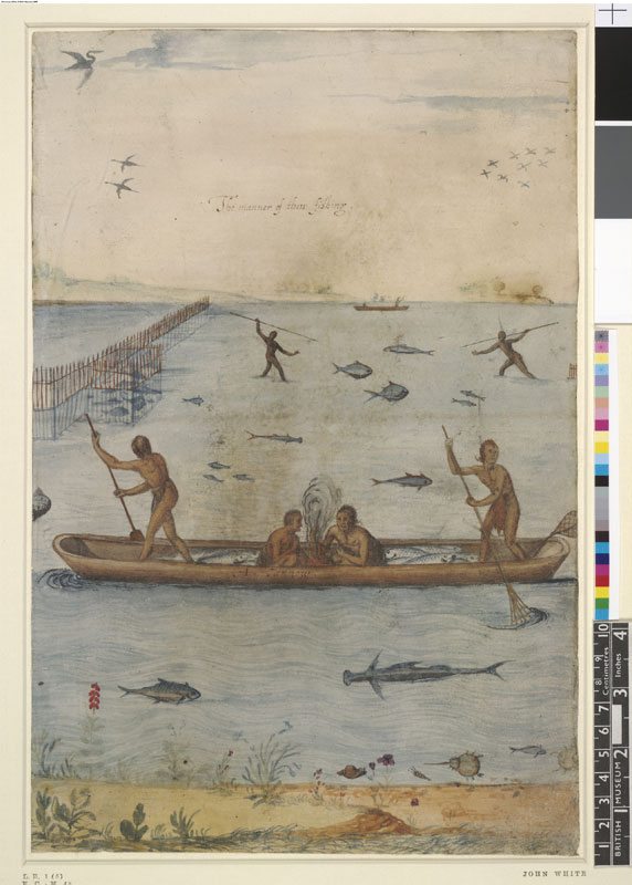
John White in Wingina
John White, the artist, visited Secotan in 1585 and made an illustration the town.
A dozen houses are scattered among the trees and along the main thoroughfare near to small open fields where tobacco, several types of corn, and garden vegetables are growing. In the foreground, wooden posts with carved faces are shown in a circle around an area of beaten earth where the people gathered to sing and dance. Adjoining is a smaller plot with five carved wooden posts and a fire in the center where people met for prayers.
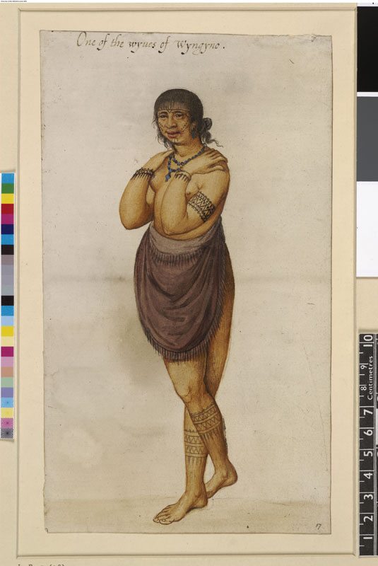
Occasionally, Wingina might have stayed at the fortified town of Pomeiooc (also illustrated by John White), situated approximately 40 miles to the east, and at Dasemunkepeuc on the mainland across the water from the island of Roanoke, where his brother, Granganimeo, ruled.
Pomouliks, Neusioks, and Coree
Inhabiting lands in the south of the region were peoples independent and hostile to the three main groups. The Pamlicos (Pomouiks), who occupied the peninsula south of the Pamlico River, and the Neuse (Neusioks) and Coree of the Neuse River, came from a different linguistic and cultural stock (Iroquoian).
At the time the English arrived they had formed an alliance against the Secotans, perhaps in league with Iroquoians who lived in the interior.
Iroquoian, Siouan, and the Tuscaroras
Territories to the west and north of the coastal lands were occupied by powerful Iroquoian and Siouan peoples. Numbering many thousands and occupying a large swath of territory from the Neuse to the Roanoke River, the Tuscaroras posed the greatest threat and pressed upon the western borders of the Chowanocs and Secotans.
How long the Tuscaroras had lived in the region is unknown but they may have arrived in a series of migrations that brought peoples from the Great Lakes (Iroquoia) to the mid-Atlantic half a millennia before. The English referred to them as Mangoacks or Mangoags.
They played an important role trading between peoples of the coast and interior, and had access to valuable deposits of copper and salt deep in the piedmont and mountains.
The Occaneechee Western Buffer
Farther to the west, the Occaneechees, an influential Siouan people inhabited the upper reaches of the Neuse River and Occaneechee Island on the Roanoke River, a major center of trade. Finally to the north, the Iroquoian Nottoway, possibly clients of the Tuscaroras, lived along the river that bears their names.
They acted as a buffer between the Tuscaroras and Chowanocs and an emerging Algonquian chiefdom in the Virginia Tidewater, the Powhatans.
James Horn
Further Reading on the Indian People of Ossomocomuck
Michael Leroy Oberg, The Head in Edward Nugent’s Hand: Roanoke’s Forgotten Indians (Philadelphia, Penn., 2007).